Joint DEM (AIA + Xray) Sept 12 2020

23.6.21 E. Lastufka

run in python 3.5

Orbit 6 (source 1)

  • still compact, this time AIA lightcurves actually match up with NuSTAR (when masks applied)
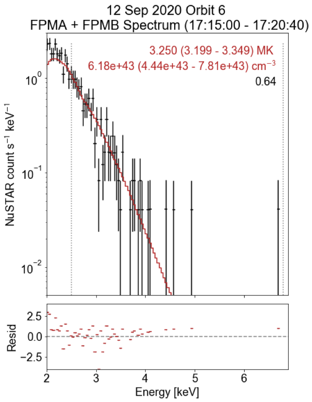
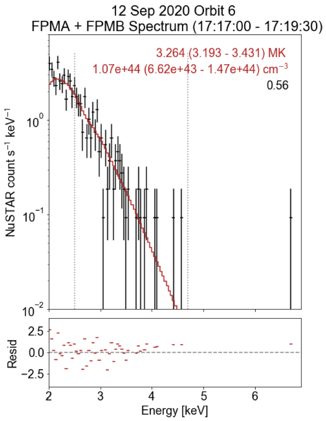
Spectra & fits

17:15-17:20:40 17:17-17:19:30

Quick sanity check: are NuSTAR response functions the same?

/Users/wheatley/Documents/Solar/NuStar/specfiles/nu80610206001A06_chu12_N_sr_orbit6_1715_1721.arf /Users/wheatley/Documents/Solar/NuStar/specfiles/nu80610206001A06_chu12_N_sr_orbit6_1715_1721.rmf
/Users/wheatley/Documents/Solar/NuStar/specfiles/nu80610206001B06_chu12_N_sr_orbit6_1715_1721.arf /Users/wheatley/Documents/Solar/NuStar/specfiles/nu80610206001B06_chu12_N_sr_orbit6_1715_1721.rmf
/Users/wheatley/Documents/Solar/NuStar/specfiles/nu80610206001A06_chu12_N_sr_orbit6_1717_1720.arf /Users/wheatley/Documents/Solar/NuStar/specfiles/nu80610206001A06_chu12_N_sr_orbit6_1717_1720.rmf
/Users/wheatley/Documents/Solar/NuStar/specfiles/nu80610206001B06_chu12_N_sr_orbit6_1717_1720.arf /Users/wheatley/Documents/Solar/NuStar/specfiles/nu80610206001B06_chu12_N_sr_orbit6_1717_1720.rmf
op6=get_obs_params(orbit=6)
op6
bl bls flare_box flare_tr obs_base_diff obs_dir obs_end obs_peak obs_start orbit ... qsbl qstr s2bl s2tr tr trs circle circle20 circle20_off circ_stereo
0 -800 -625 [-610, 30] 20200912_171600 2020-09-12T12:24:00 /Users/wheatley/Documents/Solar/NuStar/orbit6 2020-09-12T17:40:00 2020-09-12T17:18:00 2020-09-12T17:13:00 6 ... 625 -525 -900 -700 -500 -525 <SkyCoord (Helioprojective: obstime=2020-09-12... <SkyCoord (Helioprojective: obstime=2020-09-12... <SkyCoord (Helioprojective: obstime=2020-09-12... <SkyCoord (Helioprojective: obstime=2020-09-12...
1 -300 0 [-550, 90] 20200912_172100 2020-09-12T12:24:00 /Users/wheatley/Documents/Solar/NuStar/orbit6 2020-09-12T17:40:00 2020-09-12T17:18:00 2020-09-12T17:13:00 6 ... 0 -100 200 400 300 100 <SkyCoord (Helioprojective: obstime=2020-09-12... <SkyCoord (Helioprojective: obstime=2020-09-12... <SkyCoord (Helioprojective: obstime=2020-09-12... <SkyCoord (Helioprojective: obstime=2020-09-12...

2 rows × 22 columns

Initial run, hand-selected parameters (Flare X-ray peak)

tstart=5.0
tend=6.9
foo.__orbit6_defaults__()
foo.select_joint_maps()
foo.prep_joint_maps(plot_maps=True)
foo.generate_dem_input()
all maps same dimensions
not transposed
nustar cutout coords:  <SkyCoord (Helioprojective: obstime=2020-09-12 17:15:14.287000, rsun=695508000.0 m, observer=<HeliographicStonyhurst Coordinate (obstime=2020-09-12 17:15:14.287000): (lon, lat, radius) in (deg, deg, m)
    (0., 7.2309999, 1.505376e+11)>): (Tx, Ty) in arcsec
    (-656.03011814, -14.14023079)> <SkyCoord (Helioprojective: obstime=2020-09-12 17:15:14.287000, rsun=695508000.0 m, observer=<HeliographicStonyhurst Coordinate (obstime=2020-09-12 17:15:14.287000): (lon, lat, radius) in (deg, deg, m)
    (0., 7.2309999, 1.505376e+11)>): (Tx, Ty) in arcsec
    (-546.03011814, 95.85976921)>
[7.38594476e+00 9.80596618e+01 1.10959117e+03 1.89983977e+03
 7.44986990e+02 4.84496668e+01 2.59160557e+01 3.75489518e-01]
fdf=foo.run_joint_dem()
fdf[['aia_area','xrt_area']]
Input data and errors:
94 :     7.39   4.07   55 %
131 :     98.06   15.56   16 %
171 :     1109.59   166.44   15 %
193 :     1899.84   284.98   15 %
211 :     744.99   111.75   15 %
335 :     48.45   7.27   15 %
Be-Thin :     25.92   5.18   20 %
NuSTAR 2.5-3.5 keV :     0.38   0.08   20 %
chisq: 1.051624
AIA DN_reg/DN_in ratio: 0.8280841582511513
Xray DN_reg/DN_in ratio: 1.0063871117092984
aia_area xrt_area
0 1.533222e+16 8.110882e+17

Preflare DEM

using counts from images - for publication, use counts from .pha files (need Sarah to generate them for given timerange)

pf_dem=joint_DEM(tstart=tstart,tend=tend,numtemps=50)
pf_dem.__orbit6_defaults__()
pf_dem.timerange=s0tr
pf_dem.aia_mask=foo.aia_mask
pf_dem.use_NuSTAR=False
pf_dem.run_from_inputs()
all maps same dimensions
nustar cutout coords:  <SkyCoord (Helioprojective: obstime=2020-09-12 17:05:14.004000, rsun=695508000.0 m, observer=<HeliographicStonyhurst Coordinate (obstime=2020-09-12 17:05:14.004000): (lon, lat, radius) in (deg, deg, m)
    (0., 7.2310656, 1.50537869e+11)>): (Tx, Ty) in arcsec
    (-660.07714388, -13.87787809)> <SkyCoord (Helioprojective: obstime=2020-09-12 17:05:14.004000, rsun=695508000.0 m, observer=<HeliographicStonyhurst Coordinate (obstime=2020-09-12 17:05:14.004000): (lon, lat, radius) in (deg, deg, m)
    (0., 7.2310656, 1.50537869e+11)>): (Tx, Ty) in arcsec
    (-550.07714388, 96.12212191)>
no NuSTAR fits files found for timerange [1705, 1710]!
[1.4642997763841188 12.238772995749747 255.50776715192893
 455.32791397709974 95.59869202077111 5.324539199280693 12.092278480529785
 None]
Input data and errors:
94 :     1.46   2.09   142 %
131 :     12.24   4.58   37 %
171 :     255.51   38.33   15 %
193 :     455.33   68.30   15 %
211 :     95.60   14.34   15 %
335 :     5.32   2.19   41 %
Be-Thin :     12.09   2.42   20 %
chisq: 1.205421
AIA DN_reg/DN_in ratio: 0.7714975433177589
Xray DN_reg/DN_in ratio: 0.9483643205117315
aia_area aia_calc_degs aia_contour aia_exptime_correct aia_mask_channel aia_ratio aiapickle chanax chisq datadir ... nustar_timerange selfnorm tend trmatrix_use tstart use_AIA xray_ratio xrt_area xrt_fac xrt_submap_radius
0 1.533222e+16 False 75 False 171 0.771498 /Users/wheatley/Documents/Solar/NuStar/orbit6/... [94, 131, 171, 193, 211, 335, Be-Thin] 1.205421 /Users/wheatley/Documents/Solar/NuStar/orbit6/... ... [1705, 1710] False 6.9 [[[3.3205900640648614e-30, 4.3541384501921435e... 5.0 True 0.948364 8.110882e+17 1 6

1 rows × 34 columns

Decay phase DEM

using counts from images - for publication, use counts from .pha files (need Sarah to generate them for given timerange)

dc_dem=joint_DEM(tstart=tstart,tend=tend,numtemps=50)
dc_dem.__orbit6_defaults__()
dc_dem.timerange=s3tr
dc_dem.aia_mask=foo.aia_mask
dc_dem.select_joint_maps()
dc_dem.prep_joint_maps(plot_maps=True)
dc_dem.generate_dem_input()
dc_dem.run_joint_dem()
all maps same dimensions
nustar cutout coords:  <SkyCoord (Helioprojective: obstime=2020-09-12 17:21:20.821000, rsun=695508000.0 m, observer=<HeliographicStonyhurst Coordinate (obstime=2020-09-12 17:21:20.821000): (lon, lat, radius) in (deg, deg, m)
    (0., 7.23095973, 1.50537436e+11)>): (Tx, Ty) in arcsec
    (-656.0094077, -14.22019112)> <SkyCoord (Helioprojective: obstime=2020-09-12 17:21:20.821000, rsun=695508000.0 m, observer=<HeliographicStonyhurst Coordinate (obstime=2020-09-12 17:21:20.821000): (lon, lat, radius) in (deg, deg, m)
    (0., 7.23095973, 1.50537436e+11)>): (Tx, Ty) in arcsec
    (-546.0094077, 95.77980888)>
[3.53897573e+00 4.18027884e+01 6.21989350e+02 1.12871445e+03
 6.39142766e+02 4.10850696e+01 1.39912834e+01 1.04719049e-01]
Input data and errors:
94 :     3.54   2.92   83 %
131 :     41.80   8.97   21 %
171 :     621.99   93.30   15 %
193 :     1128.71   169.31   15 %
211 :     639.14   95.87   15 %
335 :     41.09   6.48   16 %
Be-Thin :     13.99   2.80   20 %
NuSTAR 2.5-3.5 keV :     0.10   0.02   20 %
chisq: 2.008126
AIA DN_reg/DN_in ratio: 0.770375704064202
Xray DN_reg/DN_in ratio: 0.9986812160070049
aia_area aia_calc_degs aia_contour aia_exptime_correct aia_mask_channel aia_ratio aiapickle chanax chisq datadir ... nustar_timerange selfnorm tend trmatrix_use tstart use_AIA xray_ratio xrt_area xrt_fac xrt_submap_radius
0 1.533222e+16 False 75 False 171 0.770376 /Users/wheatley/Documents/Solar/NuStar/orbit6/... [94, 131, 171, 193, 211, 335, Be-Thin, NuSTAR ... 2.008126 /Users/wheatley/Documents/Solar/NuStar/orbit6/... ... [1721, 1726] False 6.9 [[[3.3205900640648614e-30, 4.3541384501921435e... 5.0 True 0.998681 8.110882e+17 1 6

1 rows × 34 columns

DEM at selected times

Similar AIA and XRT areas

#original temperature range
ea_dem0=joint_DEM(tstart=tstart,tend=tend,numtemps=50)
ea_dem0.__orbit6_defaults__()
ea_dem0.timerange=s2tr
ea_dem0.aia_contour=60
ea_dem0.xrt_max=True
#ea_dem.xrt_fac=2
ea_dem0.nustar_fac=1
ea_dem0.select_joint_maps()
ea_dem0.prep_joint_maps(plot_maps=True)
ea_dem0.generate_dem_input()
eadf0=ea_dem0.run_joint_dem()
eadf0[['aia_area','xrt_area']]
all maps same dimensions
not transposed
nustar cutout coords:  <SkyCoord (Helioprojective: obstime=2020-09-12 17:18:00.842000, rsun=695508000.0 m, observer=<HeliographicStonyhurst Coordinate (obstime=2020-09-12 17:18:00.842000): (lon, lat, radius) in (deg, deg, m)
    (0., 7.23098165, 1.50537525e+11)>): (Tx, Ty) in arcsec
    (-656.02301532, -14.25961714)> <SkyCoord (Helioprojective: obstime=2020-09-12 17:18:00.842000, rsun=695508000.0 m, observer=<HeliographicStonyhurst Coordinate (obstime=2020-09-12 17:18:00.842000): (lon, lat, radius) in (deg, deg, m)
    (0., 7.23098165, 1.50537525e+11)>): (Tx, Ty) in arcsec
    (-546.02301532, 95.74038286)>
[8.52856664e+00 1.10227466e+02 1.24890263e+03 2.17698369e+03
 8.16003576e+02 5.66816863e+01 4.31181183e+01 5.23027727e-01]
Input data and errors:
94 :     8.53   4.36   51 %
131 :     110.23   16.89   15 %
171 :     1248.90   187.34   15 %
193 :     2176.98   326.55   15 %
211 :     816.00   122.40   15 %
335 :     56.68   8.50   15 %
Be-Thin :     43.12   8.62   20 %
NuSTAR 2.5-3.5 keV :     0.52   0.10   20 %
chisq: 13.690544
AIA DN_reg/DN_in ratio: 0.32840463475494924
Xray DN_reg/DN_in ratio: 0.7378866927046315
aia_area xrt_area
0 2.299833e+16 9.012092e+16
tstart1=tstart
tend1=6.6
ea_dem=joint_DEM(tstart=tstart1,tend=tend1,numtemps=50)
ea_dem.__orbit6_defaults__()
ea_dem.timerange=s2tr
ea_dem.aia_contour=32
ea_dem.xrt_max=True
#ea_dem.xrt_fac=2
ea_dem.nustar_fac=1
ea_dem.select_joint_maps()
ea_dem.prep_joint_maps(plot_maps=True)
ea_dem.generate_dem_input()
eadf=ea_dem.run_joint_dem()
eadf[['aia_area','xrt_area']]
all maps same dimensions
not transposed
nustar cutout coords:  <SkyCoord (Helioprojective: obstime=2020-09-12 17:18:00.842000, rsun=695508000.0 m, observer=<HeliographicStonyhurst Coordinate (obstime=2020-09-12 17:18:00.842000): (lon, lat, radius) in (deg, deg, m)
    (0., 7.23098165, 1.50537525e+11)>): (Tx, Ty) in arcsec
    (-656.02301532, -14.25961714)> <SkyCoord (Helioprojective: obstime=2020-09-12 17:18:00.842000, rsun=695508000.0 m, observer=<HeliographicStonyhurst Coordinate (obstime=2020-09-12 17:18:00.842000): (lon, lat, radius) in (deg, deg, m)
    (0., 7.23098165, 1.50537525e+11)>): (Tx, Ty) in arcsec
    (-546.02301532, 95.74038286)>
[4.91369431e+00 6.64082014e+01 8.03773082e+02 1.30944451e+03
 4.81824979e+02 3.36896091e+01 4.31181183e+01 5.23027727e-01]
Input data and errors:
94 :     4.91   3.37   69 %
131 :     66.41   11.97   18 %
171 :     803.77   120.57   15 %
193 :     1309.44   196.42   15 %
211 :     481.82   72.27   15 %
335 :     33.69   5.67   17 %
Be-Thin :     43.12   8.62   20 %
NuSTAR 2.5-3.5 keV :     0.52   0.10   20 %
chisq: 1.698725
AIA DN_reg/DN_in ratio: 0.8210003497757915
Xray DN_reg/DN_in ratio: 0.7884920017546538
aia_area xrt_area
0 8.816028e+16 9.012092e+16